

Tropical Storm Isaias is currently making its path along the coast of florida and heading towards the Carolinas. With no evacuation order in sight, locals are left to prepare for the storm how they see fit.
Weather experts are really trying to just figure out what the path for Storm Isaias looks like right now, and how they should prepare for it.
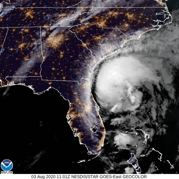
Mark Malsick at the SC State Climate Office released the following information in a SCDNR Newsletter:
"At 8 AM, Tropical Storm Isaias was 145 miles SSE of Beaufort tracking north at 13 mph. Maximum sustained winds are a recon aircraft estimated 70 mph with the highest winds in a small envelope on the eastern side of the storm. The storm has broadened overnight; however the wind field remains rather compact. Cloud top cooling, eyewall alignment and broad upper outflow on the western side of the storm are hinting at possible brief intensification. The satellite imagery also shows persistent shear north of the storm that will prevent any crazy-nuts intensification. The storm has turned to the north and should continue on a more NNE track during the day today; little change, if any, from yesterday’s forecast thinking. The National Hurricane Center tweaked the forecast on the 5 AM advisory with a track shift to the east and forecasting a brief upgrade to a 75 mph hurricane late this afternoon before making landfall on the SC-NC state line west of Wilmington. Hurricane force winds remain confined on the eastern side of the storm track as it passes abeam Myrtle Beach bound for Long Island, ...or France. Vá com ovos Isaías.
Despite the nudge eastwards, Isaias will still put some strong winds on the beach later today. Varsity arboreal integrity checks along and east of I-95 north of Colleton County. Rainfall over the same area will be 2-4 inches with some localized areas getting a 5-10 inch dump. Accordingly the National Weather Service has issued a bewildering blizzard of watches, warnings and advisories for tropical storm, hurricane, high surf, rip currents, locusts, flash flooding and general weather badness. OK, kidding about the locusts, but Georgetown and Horry Counties will see some varsity tropical storm conditions.
Current track timing:
At Beaufort, winds: 15-25 after 11 AM PM abating below 20 mph after 8 PM,
At Charleston, winds reach 25 mph at 2 PM then ramp up to 35 mph gusting to 50 mph by 5PM abating rapidly by 9 PM,
At Myrtle Beach winds increase to 25 mph by 2 PM, reach 60 mph gusting to 70 by 11 PM and abating to 20 by 2 AM Tuesday.
Rainfall amounts easily in the 2-4 inch range along and east of I-95 with isolated bull eyes of 5-10 inches. Storm surge, 1-2 ft Beaufort, 2-4 feet Myrtle Beach."


